November / December 2022 Newsletter

Ridge Route Preservation Organization Accomplishments

What have we done? Why donate to us? Why join us?

The Ridge Route Preservation Organization has accomplished quite a bit so far. We can’t do it without your support. We have a lot more to do!

Here is a short list of some of those.

  • Created the 501(c)3 Non-Profit Public Benefit Ridge Route Preservation Organization in January 2001.
  • Placed the Historic Ridge Route onto the National Register with the help of Angeles National Forest Archaeologist Michael J. McIntyre September 25, 1997
  • Established a Memorandum of Understanding (Now a Volunteer Service Agreement) with the Angeles National Forest which allowed our organization to clear minor landslides and fill potholes.
  • Reservoir Summit was the mutual agreed location where we deposited dirt cleared from the road that it created a small mountain known as “Scotty’s Mountain”.
  • Initiated the CUTRR “Clean Up The Ridge Route” program that met monthly to clean out the drains on the road.
  • Identified all drains on the road and marked and numbered each one with a state approved marker.
  • Stepped in to complete posting Picture Placards on concrete monuments provided by a non-profit organization that went out of business.  Photo posted at each historic site from the Harrison I. Scott archives.
  • Contacted the Federal Highway Administration in Colorado (the nearest office) and offered to fly them out at our expense to examine the major landslides on the Ridge Route from the January 2005 “one -hundred – year rainstorm”.   The Federal Highway Administration repaired the road working with Angeles National Forest.
  • Replaced the steps at the Tumble Inn historic site that were being damaged by off road motorcyclists in cooperation with late Ranger Bob Blount.
  • Former President, Harrison I. Scott brought further attention to the historic Ridge Route by doing two over the road television programs.  First, a one – hour program going over the road with Huell Howser in a 1915 Model T.  A one – half hour program going over the road in Jay Leno’s 1915 Franklin.

There is a lot more we need to do. We are still working, albeit slowly, on getting the roadway reopened. We need your help with our Ridge Route Management Plan, which we will submit to the Angeles National Forest as a part of the opening plan. We will be holding Zoom meetings again soon regarding this plan and more. Make sure to subscribe to our website to learn more.

RRPO Board Update – Treasurer Needed

Our current Treasurer, Richard Valot, will be resigning by the end of the 2022. We wish to thank him for his many years of service and wish him well! We are looking for a new person to fill the position and help us move forward. If you are interested in learning more about the position or are interested in applying, please contact us!

Ridge Route Mapping Update

Our mapping project is nearly complete! Our base map is done and now we are working on adding other features. Once it is available, we will make an announcement on the site where it can be viewed.

RRPO YouTube Channel

Did you know we have a YouTube channel with videos on the history of the Ridge Route and various aspects of the current status of the roadway? We’ve posted a few videos recently showcasing some of the unique history of the roadway. Check it out and subscribe!

https://www.youtube.com/channel/UCSVYTEajHIx-G4jewzHlvxg

Upcoming Articles – We Want to Hear from You!

Would you like to write an article for our newsletter? We are looking for stories about the road, experiences you’ve had, or information about the history. Perhaps something about the things you can see alongside the roadway, such as the plants and geology. Let us know! We’d love to hear about it!

Featured Photo

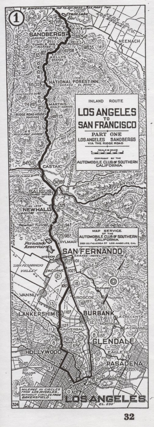
From our archives – a 1921 Automobile Club of Southern California strip map showing the Ridge Route from Los Angeles to State 138. Some things to note are modern Quail Lake being named Crane Lake, Castaic being shown further south (train station was located at current Castaic Junction), the Newhall Tunnel still in place, and the option of going via Cahuenga Pass instead of along current San Fernando Road.

September-October 2022 Newsletter

Ridge Route Update

Fallen tree along the north Reservoir Summit grade

It has been a while since our last update. I’ve been busy with a move and house remodeling, which has taken me away from things. Unfortunately, we don’t have a lot to report. We are still working with the USFS to get the roadway open and develop a management plan for the roadway.

Over the weekend of August 20, I was able to take a trip over the Ridge Route to survey the roadway. For the most part, there was good news. The roadway is still in pretty good shape. Earlier this year, utility crews cleared large portions of the road from Serpentine Drive to near Sandberg. That work has helped to keep the roadway in better shape over the summer and hopefully into the coming winter. Only small rockslides were found at Swede’s Cut and below Reservoir Summit on the north side of the summit.

Swede’s Cut prior to being cleared.

In early August, a small fire occurred at the north end of the Ridge Route where it meets State 138. The fire, known as the Sam Fire, was held at 150 acres and didn’t cause any damage to the Ridge Route. It did burn along State 138 from the Ridge Route to the California Aqueduct and partially up Bald Mountain. An additional fire started on August 31, known as the Route Fire, near the southern end of the Ridge Route along northbound I-5. It is not known at this time if the Ridge Route is affected though it has progressed to the Callahan Line Change site as of 1600 on August 31.

The roadway is still closed at this time even though there have been reports of the gates being left open. Keep in mind, the gates can be closed and locked behind you, so please do not travel beyond them by motor vehicle. Travel is still allowed via walking, horseback, and bicycling.

RRPO Update

Our current Treasurer, Richard Valot, will be resigning by the end of the 2022. We wish to thank him for his many years of service and wish him well! We are looking for a new person to fill the position and help us move forward. If you are interested in learning more about the position or are interested in applying, please contact us!

Ridge Route Mapping Update

We are working on a comprehensive map of the Historic Ridge Route using the Google API. We are hoping to have this available in the near future. If you are interested in learning more or would like to help contribute, let us know.

RRPO YouTube Channel

Did you know we have a YouTube channel with videos on the history of the Ridge Route and various aspects of the current status of the roadway? We’ve posted a few videos recently showcasing some of the unique history of the roadway. Check it out and subscribe!

https://www.youtube.com/channel/UCSVYTEajHIx-G4jewzHlvxg

Reporting Problems on the Ridge Route

With all the recent fire activity as well as other events such as January 26 when big rigs tried to travel the Ridge Route, we thought it was a good idea to have a place to report things. If you see something wrong on the Ridge Route, be it a developing washout, large vehicles traversing the roadway, or things out-of-the-ordinary, we have have set up a web page to help you report things on the road. We will pass the information along to the appropriate agencies as needed.

To Report Problems or other issues on the Ridge Route, please use the website below. The web page is also located under our “Current Roadway Conditions” page in the menu.

Upcoming Articles

Would you like to write an article for our newsletter? We are looking for stories about the road, experiences you’ve had, or information about the history. Perhaps something about the things you can see alongside the roadway, such as the plants and geology. Let us know! We’d love to hear about it!

Featured Photo

Gorman in 1958. Courtesy – Caltrans

This month’s photo comes to us from Caltrans and shows the town of Gorman as it was in 1958. The Ridge Route proper can be seen in the distance to the right. In the foreground near the bottom of the photo, a short section of original 1917 paving can be seen as a small diagonal roadway ending near the Gorman Motel site. This was realigned in June 1933 when the Ridge Route Alternate was under construction. While gated, the roadway remains today and can still be seen off of Gorman Post Road just south of Gorman School Road.

May – June 2022 Newsletter

Superelevated curves heading down the north Reservoir Summit grade

Roadway Update

We have some good news regarding the condition of the roadway. Southern California Edison and other contractors recently completed a project to replace some of the wires on their power lines. To make sure the vehicles they used could traverse the roadway and not do any damage, they cleared the roadway. The large rockslides in Swede’s Cut and Serpentine Drive reported in January have been removed. The large boulder that was moved during our August 2021 CUTRR was broken down yet more and moved further from the roadway. The gates still remain closed and the roadway between the gates is only open to non-motorized travel.

CUTRR Events and Online Meetings

Our CUTRR events are currently on hold due to personal obligations. They will resume as soon as possible. We are also working with the USFS to get permission to use heavier equipment / mechanized tools to increase our efficiency. Thank you all for your patience and continued support.

Our online meetings should resume soon. I am working on a date for May at this time. Previous meetings have been quite successful, and I would like to keep that going. Your input has been very helpful. Future meetings will be recorded, as requested through our recent poll. If you miss a meeting, it will be posted on our YouTube channel.

Website Subscription

Make sure to subscribe to our site to get updates on upcoming CUTRR events and Ridge Route news.

Reporting Problems on the Ridge Route

Events such as January 26, 2021 when big rigs tried to travel the Ridge Route and past fires, we thought it was a good idea to have a place to report things. If you see something wrong on the Ridge Route, be it a developing washout, large vehicles traversing the roadway, or things out-of-the-ordinary, we have set up a web page to help you report things on the road. We will pass the information along to the appropriate agencies as needed.

To Report Problems or other issues on the Ridge Route, please use the website below. The web page is also located under our “Current Roadway Conditions” page in the menu.

Upcoming Articles

Would you like to write an article for our newsletter? We are looking for stories about the road, experiences you’ve had, or information about the history. Perhaps something about the things you can see alongside the roadway, such as the plants and geology. Let us know!

Featured Photo

Swede’s Cut, shortly after opening of the Ridge Route in 1915

Swede’s Cut, is the largest and most famous cut along the Ridge Route. It slices through a ridge at 110 feet in depth. The cut is also the source of many rockslides, due to the steep sides and easily broken sedimentary layers within. We do hope to see it as clear as it was in 1915 someday. With your help, we will make that happen.

January / February 2022 Newsletter

Ridge Route Update

On December 18, 2021, we went on an inspection trip over the Ridge Route to assess what the latest storms have done to the roadway. What was saw was very mixed but encouraging overall. Small rockslides were common from Serpentine Drive all the way to Sandberg. Some were a bit larger and will require tools to remove. We did remove many smaller rocks along the way and cleared the roadway to the best of our ability. Our next CUTRR event is still in the works but will involve clearing a few drains between Kelly’s and Reservoir Summit and rock removal at Serpentine Drive.

As we are in a somewhat rainy season, use extra caution when traveling the roadway. Whether the gates are open or not, do not travel the road just after or during a storm. Rockslides could trap you, the gates could be closed behind you, and you will likely damage the roadway in the process. We appreciate your support and understanding.

Rocks covering the roadway, again, at the August worksite on Serpentine Drive. Courtesy – Michael F Ballard
Eventually, we’d like to move this boulder even further. The fact it remains the largest on the road is somewhat encouraging at least. Courtesy – Michael F Ballard
Largest rockfall on Serpentine Drive, just north of the August worksite. A few hits with a hammer should break these down for removal. Courtesy – Michael F Ballard
Swede’s Cut was passable but needed a lot of work. Courtesy – Michael F Ballard
Blocked culvert near Reservoir Summit, causing material to accumulate on the roadway. Courtesy – Michael F Ballard
Between Kelly’s and the Tumble Inn. This puddle is the result of poor drainage and must be fixed. The original pavement can’t even be seen here. Courtesy – Michael F Ballard

Monthly Meetings via Zoom

We are working on putting together monthly meetings, open to the public, to talk about the Ridge Route, what is happening, future CUTRR events, and its history. There is a lot going on and things are looking positive for the Ridge Route, more than they have in the past. These meetings will be online via Zoom. We want to get more people engaged in our continuing efforts to reopen the roadway and help keep it preserved. The schedule is still being worked out, so make sure you’re subscribed to our website to stay informed. Our first meeting is likely to be held in late January.

Public Forums

In the next few months, we are planning to start an online forum on our website for the Ridge Route where you can swap stories, learn about the roadway, and share your knowledge of the roadway. These will be open to all, with some sections being for RRPO members only. Stay tuned for more details!

Website Subscription

Make sure to subscribe to our site to get updates on upcoming CUTRR events and Ridge Route news.

Reporting Problems on the Ridge Route

With all the recent fire activity as well as other events such as January 26 when big rigs tried to travel the Ridge Route, we thought it was a good idea to have a place to report things. If you see something wrong on the Ridge Route, be it a developing washout, large vehicles traversing the roadway, or things out-of-the-ordinary, we have have set up a web page to help you report things on the road. We will pass the information along to the appropriate agencies as needed.

To Report Problems or other issues on the Ridge Route, please use the website below. The web page is also located under our “Current Roadway Conditions” page in the menu.

Featured Photo

North of Reservoir Summit. Courtesy – Michael F Ballard

One of the many interesting features along the Ridge Route is the superelevated roadway. Between Reservoir Summit and Kelly’s Halfway Inn, this reaches a “fever pitch”, with the pavement acting like a warped ribbon across the mountain. It is one of my favorite sections of roadway. What is your favorite part of the road?

November – December 2021 Newsletter

Ridge Route Update

With winter coming, we will be shutting down our CUTRR projects until March or April 2022, depending on how winter goes. Planning gets to be a bit more difficult when dodging rain and snow storms. Those same storms also bring additional hazards to the historic roadway. To ensure both yourself and the roadway stay as safe as possible, please do not travel the roadway during or just after a heavy rain or snow storm. Mud, rocks, and other debris may be present on the roadway blocking the roadway. The concrete paving is also most vulnerable during this period and can be easier to break with a wet base. We can all do our part to help keep the roadway safe.

Overall, the roadway is in decent shape with some major exceptions. Those exceptions are a part of our CUTRR goals and what we intend to get the USFS to repair as needed. The gates at both ends remain closed and as always, if you see them open DO NOT expect them to remain open for the duration of your visit. USFS, utility companies, and other groups with access may close the gates behind them.

We are working with the USFS to “upgrade” our relationship with them as well as get approvals to use heavier equipment, such as skid-steers and scrapers. Using them will allow us to clear the roadway a lot easier and with greater speed while still ensuring the historic roadway remains intact. Our last two events have mostly used hand tools, which we still will use for smaller projects and to clear brush as needed. I do wish to thank ALL that have contributed to the success of these events, in any way they have contributed. Some have done so financially, others brought tools, many others have been helping swing picks and clear debris. We couldn’t, nor could we continue, to do this without all your efforts. Thank you Ridge Route volunteers!

October 23, 2021 CUTRR Event Report

CUTRR crew hard at work

We had another successful CUTRR event on the 23rd. We set the date later in October with the hopes the weather would be cooler and the fire danger would have subsided. We got that and more. It rained a bit the night before, but not enough to cancel or cause a problem. It rained / drizzled yet more when we all met in Gorman. However, when we got to the work site, the weather was near perfect.

The work was hampered a fair amount due to the lack of heavier equipment. Should we do this again without skid-steer/bobcat-type equipment, we intend to use powered tools, such as jackhammers and the like to break up and remove the debris from the roadway. We hadn’t really used such equipment in the past and I hadn’t considered it before as a result.

Despite using just hand tools, we made really good progress, thanks to our volunteers. The drain was cleared, channels were dug to help direct the water better, and a decent amount of material was removed to help prevent this from getting worse. Repairs to the drainage culvert will be necessary in the near future, however, as it is starting to rust and develop holes.

Finished for the day.

If you’d like to help plan the next CUTRR event, let us know! We can use the help.

Website Subscription

Make sure to subscribe to our site to get updates on upcoming CUTRR events and Ridge Route news.

Reporting Problems on the Ridge Route

With all the recent fire activity as well as other events such as January 26 when big rigs tried to travel the Ridge Route, we thought it was a good idea to have a place to report things. If you see something wrong on the Ridge Route, be it a developing washout, large vehicles traversing the roadway, or things out-of-the-ordinary, we have have set up a web page to help you report things on the road. We will pass the information along to the appropriate agencies as needed.

To Report Problems or other issues on the Ridge Route, please use the website below. The web page is also located under our “Current Roadway Conditions” page in the menu.

Featured Photo

Ridge Route in Castaic with Castaic Dam in the right background. Courtesy – Michael F Ballard

This month’s featured photo shows a section of the Ridge Route which seems insignificant, but contains a great deal of history. It was taken on Castaic Lake Drive just north of the Castaic Lagoon entrance. This location marks the end of the 1915-1917 Saugus to Castaic paving, the 1922 widening of the 1917 paving (the small strip of concrete at the edge of the roadway), the beginning of the “true” Ridge Route 20′ wide paving, the first curve on the Ridge Route, and the former junction with Elizabeth Lake Canyon Road (now Lake Hughes Road). Come check out this unique piece of Ridge Route history next time you visit Castaic or Castaic Lake.